Satellite Images of Planet Earth
By Jim Plaxco, 07/23/2016
Earlier this week I created a new collection of imagery as a part of my portfolio on Redbubble. Titled Planet Earth Satellite Imagery, it is a collection of satellite images of Earth captured from space by various Earth-orbiting satellites. Strangely the start of this project was a quest to find and either delete or move to backup disks files in order to free up space on my computer's two hard drives. In searching through the thousands of directories on my drives I came across some satellite remote sensing images that I had worked with but never done anything with. Being easily distracted, I decided to play around with performing some image processing on them. One thing lead to another and I found myself downloading new imagery to work with. It was at this point that I decided to add some of these images to my Redbubble portfolio.
As of the date of this writing, the collection of images consists of:
- Bahamas Andros Island Nassau Caribbean
- Bighorn National Forest Wyoming
- Brazil Lencois Maranhenses National Park Sao Marcos Bay
- Chicago Illinois Winter
- Galapagos Islands Ecuador
- Great Salt Lake Utah
- Grand Canyon National Park and Northern Arizona
- Panama Canal Central America
- Southeast Yemen
- Volga River Delta Russia False Color
Planets and Stars
It has been a long time since I have worked with satellite imagery and the satellite data I generally worked with was not of the Earth observation variety. For the most part I worked with satellites that were orbiting Mars. Working with imaging data from the Viking Orbiters and Mars Global Surveyor satellites was my introduction to image processing. I was pleased to have my work honored by NASA when it selected one of my images as one of forty five images of Mars to be included in a special exhibit to celebrate the 30th anniversary of the Viking 1 Lander's touchdown on Mars.
In addition to working with these NASA images of Mars, which are stored in the PDS (Planetary Data System) data format), I also spent some time working with astronomical images - which use the FITS (Flexible Image Transport System) data format. I worked with astronomical images from the Hubble Space Telescope, as well as imaging data from a few other missions as well as Earth-based observatories with the primary goal being to understand the process rather than using it as a means to "make art". With respect to my work with astronomical and planetary image processing, what I am most proud of was having the opportunity to teach a class about planetary and astronomical image processing for the Adler Planetarium in Chicago.
Just to clarify, planetary science missions image files use a data format simply called Planetary Data Science with a corresponding file extension of PDS. The imaging data is composed of one or more grayscale (black and white) image files with each file representing a separate exposure taken at a specific wavelength. An analogy would be a photographer taking three black and white photographs of a scene, one using a red filter, one using a green filter, and one using a blue filter. These separate images would then be combined in order to create a color photograph. Not a problem unless you and/or your subject move between individual exposures. The same principal applies with respect to astronomical images and their FITS file format.
Goodbye Space, Hello Generative
In recent years my focus has turned to producing works of algorithmic and generative art using programs of my own design. While I have created both space art and astronomical art, I had completely stopping working with astronomical and planetary imaging data. Creating art using generative and algorithmic techniques will continue to be my focus going forward because of the pleasure I derive from the creation of new software for creating digital art. Two recent articles I've written that may provide useful insights into my thinking are:
Working with Satellite Data
Working with Earth-orbiting satellite images is not all that different than working with astronomical or planetary mission images. The principal similarity is that you are constructing a color image by stacking a series of grayscale images. To illustrate the process I am going to use as an example of imaging data that of the Landsat 8 satellite. Imaging data from the Landsat satellite is stored in a format called GeoTIFF. GeoTIFF is simply a TIFF image file that adds georeferencing data to the TIFF file's metadata. This means that unlike FITS and PDS data files, GeoTIFF files can be opened and edited by any software that can open and edit TIFF files. In my case I've used Adobe Photoshop.
Recall how I said I got re-started on this while trying to free up space on my hard drive. Well, in the case of Landsat 8 files, they are huge. A single Landsat 8 data file is approximately 900 megabytes! And that is the zipped file size. Unzipped, you've got a collection of files that totals just shy of two gigabytes! Why so large? There are two reasons.
One factor affecting the size of graphic files is the bit depth or bits per channel. In terms of bits per channel, a typical RGB image has three color channels: a red channel, a green channel, and a blue channel. Each of these channels uses 8 bits (1 byte) per pixel to specify the amount of light for that pixel. The range of values is from 0 for black to 255 for white - because 255 is the largest integer that can be stored in 8 bits. You've probably heard mention of 24-bit color. This comes from the addition of the 8 bits of red data plus the 8 bits of green data plus the 8 bits of blue data. Landsat 8 GeoTIFF images use 16 bits per channel. This means that the range of light values for a single pixel is from 0 (black) to 65,535 (white) resulting in 48-bit color. The bottom line is that a 16 bits per channel image uses twice as much storage space as the equivalent 8 bit per channel image.
The second reason for the huge file size is that you are not downloading just one image. Instead you are downloading a total of 12 images file. There is one file for each of the eleven spectral bands that Landsat "sees" in. Each of these files corresponds to a single color channel. So whereas an RGB image has three color channels, a Landsat image has 11 color channels. In addition to the eleven band files, there is also included a Quality Assessment (QA) image which is a 16-bit mask for marking out clouds, fill data, and some land cover types. The following table provides an overview of each of the eleven image files.
| Band | Bandwidth/Wavelength (nanometers) | Resolution (meters) | File Size (megabytes) |
|---|---|---|---|
| 1 | 430 – 450 | 30 | 127 |
| 2 | 450 – 510 | 30 | 127 |
| 3 | 530 – 590 | 30 | 127 |
| 4 | 640 – 670 | 30 | 127 |
| 5 | 850 – 880 | 30 | 127 |
| 6 | 1570 – 1650 | 30 | 127 |
| 7 | 2110 – 2290 | 30 | 127 |
| 8 | 500 – 680 | 15 | 509 |
| 9 | 1360 – 1380 | 30 | 127 |
| 10 | 10.6 – 11190 | 100 | 127 |
| 11 | 11.5 – 12510 | 100 | 127 |
Table 1. Landsat 8 Image Files: Bandwidth, Resolution, and Size
The following illustration of the electromagnetic spectrum provides a visual reference to the location of the Landsat Bandwidth/Wavelengths within the visible spectrum. You will notice that some of the Landsat wavelengths lie outside the range of visible wavelengths and are instead in the infrared portion of the electromagnetic spectrum. You may also have noted that the file size for band 8 is four times as large as the other files. This is a consequence of band 8 having twice the resolution of bands 1-7. With respect to resolution, a single pixel in a Landsat 8 image covers a ground surface area that is roughly the same size as a major league baseball diamond.
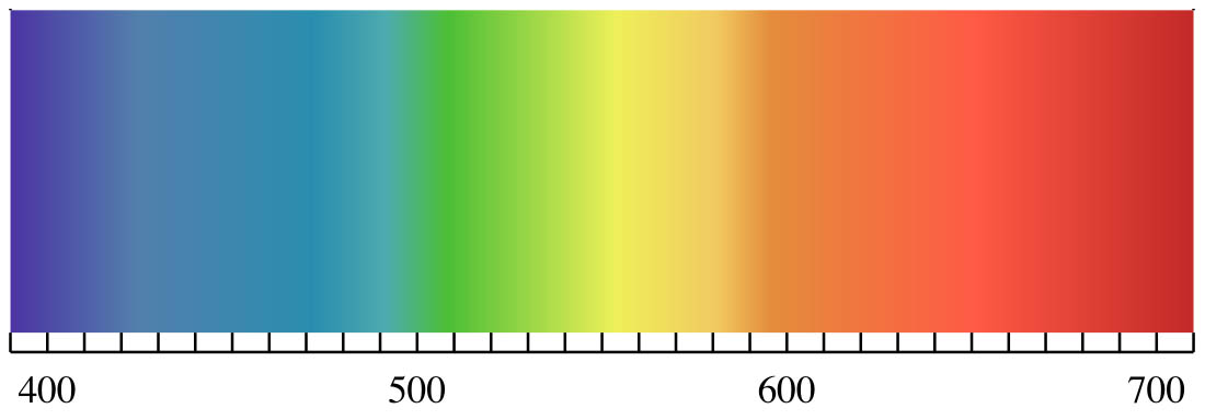
Illustration 1. Visible Light Spectrum with wavelength in nanometers
Building A Color Image
Fortunately to construct a natural color image only three of the eleven bands collected by Landsat are required. It is standard to use bands 2, 3, and 4. To construct a color image means stacking the three images taken at these different bandwidths and assigning a unique color to each of the them.
To illustrate the process of creating a color image from three grayscale (black and white) images, I am going to use a photograph of the Earth that was taken by the Apollo astronauts on their journey to the Moon. Shown below are the individual images for the red, green, and blue channels which I have already "colored" red, green, and blue.
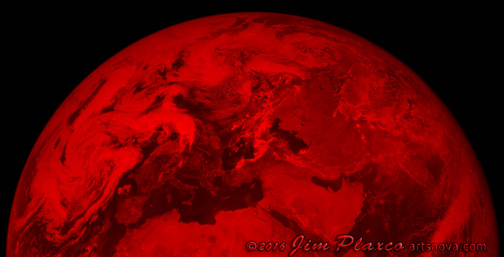
Illustration 2. Planet Earth Apollo Image Red Channel
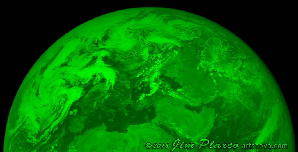
Illustration 3. Planet Earth Apollo Image Green Channel
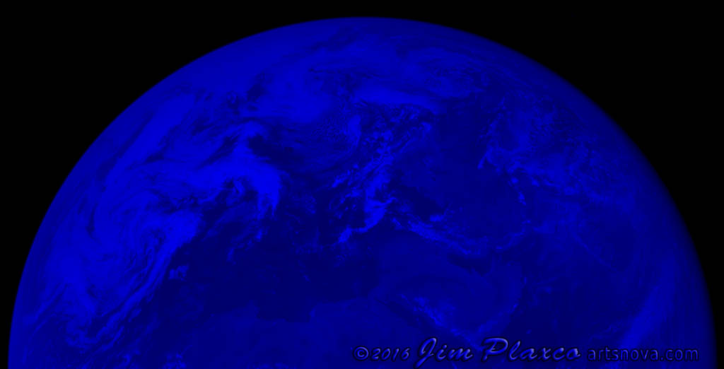
Illustration 4. Planet Earth Apollo Image Blue Channel
When these individual images are correctly stacked on top of one another and assigned the correct color, the result is the full color image in Illustration 5.
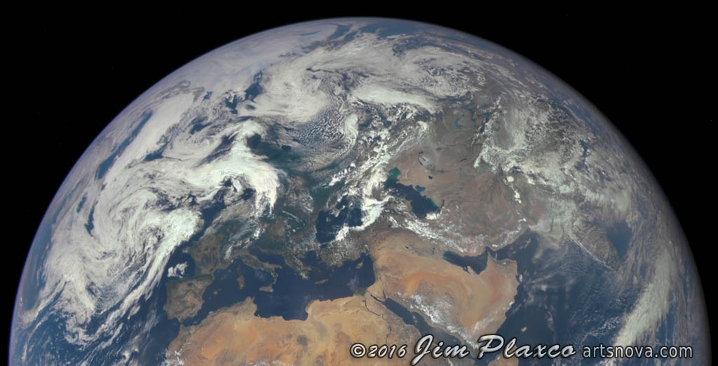
Illustration 5. Planet Earth Apollo Image RGB Composite
By manipulating the histogram and levels of the pixel values in each of the three grayscale images, a contrast and color enhanced version of the image can be produced as shown in Illustration 6 where the left side shows the original color image and the right side shows the enhanced version.
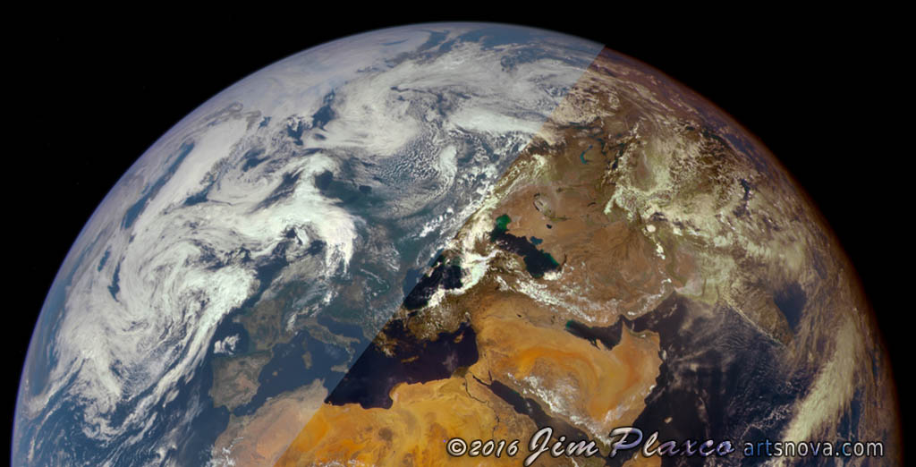
Illustration 6. Planet Earth Apollo Image RGB Composite
left: original, right: enhanced
As you may have guessed, creating an aesthetically pleasing image is something of a trial and error process. If you would like to learn more about the Landsat satellite and program, see the NASA GSFC Landsat 8 Overview.
In closing, I hope that you take the opportunity to check out my Planet Earth Satellite Image Collection on Redbubble and spend some time appreciating the beauty of Planet Earth.